
Transportation
Global reach and competitiveness in the true heartland of Florida: The Good Life of DeSoto County is now opening great opportunities for your business.
Multi-modal logistical assets open easy access to domestic and global markets.
DeSoto County offers swift movement, inbound or outbound, and fast arrival at domestic and global destinations, thanks to Florida’s first-class infrastructure, our own extensive multimodal connections, and our strategic location outside urban congestion zones.
High-Powered Highway Network:
Uncongested 360˚ highway access to all parts of the state on I-75, I-4, I-95, and on the expanded US 17 Corridor. Florida’s investment in our region’s roads puts your business in the lead.
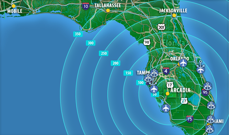
Global Air Connections:
- Tampa International Airport - 91 miles
- Orlando International Airport - 112 miles
- Southwest Florida International Airport, Ft. Myers - 56 miles
- Sarasota-Bradenton International Airport - 49 miles
- Punta Gorda Airport, 25 miles
- Arcadia Municipal Airport, FDOT's 2020 General Aviation Airport of the Year, 2.2 miles
Dual Rail Accessibility:
CSX and Seminole Gulf Railway connect to Florida’s statewide rail network, stretching from Jacksonville to Tampa, Palm Beach to Pensacola.
One-Stop Global and Domestic Shipping through the “Wharf of America,” Florida’s Peninsula-wide Port System:
Fast access to 14 Florida ports, including proximity to two ports dredged and prepared for post-Panamax vessels:
- Port of Manatee - 58 miles (post-Panamax)
- Port St. Petersberg- 74 miles
- Port of Tampa- 88 miles
- Port of Palm Beach- 124 miles
- Cape Canaveral Port- 156 miles
- Port Everglades- 163 miles
- Port of Miami - 176 miles (post-Panamax)
- Logistical Support: As Florida readies to compete aggressively for Southeast Asia import/exports, DeSoto puts your company in prime position to benefit.
Just the Facts:
Punta Gorda - 26 miles
Eastern
863
Arcadia
I-75, and excellent State Road Access to I-95 and I-4
US-17
SR 31, SR-70, SR 72
CSX, Seminole Gulf Railway
Arcadia Municipal Airport
Punta Gorda Airport
Port Manatee (49 miles)
Port of Tampa (89 miles)
ADD ITEM TO REPORT
As you navigate our website, you can use the “Add to Report” button to add any page or property to a custom report that you can print out or save. For full functionality, be sure to check the checkbox in the "Cookies Policy" area at the bottom of the page to allow us to save your selections via cookis for return visits.